Jamestown (CSi) South central and Southeast North Dakota slowly dries out from heavy rain from the weekend. On Saturday evening the event began in Jamestown and the area with thunderstorms that trained through early Sunday morning. Some pea size hail occurred around midnight Saturday in Jamestown. On Saturday The National […]
WeatherNews
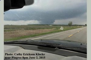
Tornado near Pingree 8pm Tuesday
Viewer submitted photo: Cathy Erickson Klocke caught this sight of a tornado around 8pm tonight, between Buchanan and Pingree, closer to Pingree. The tornado watch for Stutsman & Barnes expired at 10 pm Tuesday.
Frost Advisory Sat AM
Including the Jamestown Area…. THE NATIONAL WEATHER SERVICE IN BISMARCK HAS ISSUED A FROST ADVISORY…WHICH IS IN EFFECT FROM 2 AM CDT /1 AM MDT/ TO 9 AM CDT /8 AM MDT/ SATURDAY. TEMPERATURE…LOWER TO MIDDLE 30S. IMPACTS…TENDER OUTDOOR VEGETATION MAY BE KILLED IF LEFT UNPROTECTED. […]
Heavy rains drench region Sat & Sun – photos
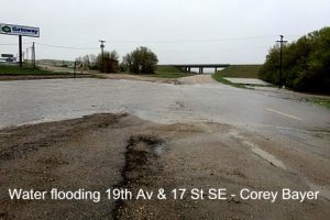
Jamestown (CSi) Heavy rains drenched the Jamestown area this past weekend, starting with training thunderstorms Saturday evening, and continuing on Sunday with periods of heavy rain, followed on Sunday evening and overnight with snow, and sleet. Through Saturday & Sunday, the Weather Station at Jamestown Airport had recorded 5.29 inches of rain this weekend. […]
Weather Service to issue spring frost freeze advisories
THE NATIONAL WEATHER SERVICE OFFICE IN BISMARCK WILL BEGIN ISSUING FROST ADVISORIES…FREEZE WATCHES…AND FREEZE WARNINGS FOR WESTERN AND CENTRAL NORTH DAKOTA ON FRIDAY MAY 1ST, 2015. A FROST ADVISORY…WILL BE ISSUED WHEN THE TEMPERATURE IS EXPECTED TO BE 33 TO 36 DEGREES FAHRENHEIT OVER A GEOGRAPHICALLY SIGNIFICANT AREA DURING […]
Devils Lake, Stump Lake flood potential
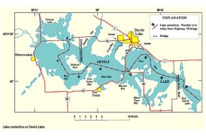
National Weather Service eastern North Dakota Grand Forks ND 0856 AM CDT Fri Apr 24 2015 Devils and Stump Lakes Long-Range Probabilistic Outlook Chances of Devils and Stump Lakes rising above given lake levels… The probability of exceeding a given lake level is the percentage of maximum lake level rises that are […]
Present burn ban info, terminology
Stay up to date on fire danager information for Stutsman County on line at http://www.co.stutsman.nd.us/fire-danger.html for daily updates, on conditions. The Governor’s declaration/burn ban is in effect through April 15, 2015, unless rescinded or extended. Stutsman County Emergency Manager, Jerry Bergquist says, unlike burn bans in the past that were declared […]
Statewide fire emergency declared
BISMARCK, N.D. – Gov. Jack Wednesday declared a fire emergency for the state in response to dry conditions, unseasonably high temperatures and high winds. In his executive order, Dalrymple issued a burn ban for areas in the North Dakota Fire Danger Rating designated as “High,” “Very High,” or “Extreme,” and/or […]
Snow events in forecast
…SEVERAL SHOTS OF SNOW OVER THE NEXT FIVE DAYS FOR WESTERN AND CENTRAL NORTH DAKOTA… FOR FRIDAY…SNOW WILL FALL THIS MORNING ALONG THE CANADIAN BORDER WITH MOST PLACES GETTING AN INCH OR LESS. HOWEVER…IN THE BOTTINEAU ..ROLLA…RUGBY AREAS…BETWEEN 2 AND 4 INCHES WILL FALL. THEN FOR SATURDAY AND […]
Snow with 1-4 inches possbile
FOR WED MAR 18, 2015 ACCUMULATING SNOWFALL EXPECTED WEST THROUGH SOUTH CENTRAL NORTH DAKOTA TUESDAY EVENING THROUGH WEDNESDAY EVENING… SNOW IS FORECAST TO DEVELOP LATE THIS EVENING ACROSS SOUTHWEST NORTH DAKOTA AND THEN SPREAD INTO THE SOUTH CENTRAL BY EARLY WEDNESDAY MORNING. SNOW IS EXPECTED TO CONTINUE THROUGH WEDNESDAY […]