 CSi Weather…
.TONIGHT…Mostly cloudy. A 30 percent chance of snow showers after midnight. Lows 15 to 20. Northwest winds around 5 mph.
.FRIDAY…Mostly cloudy. A 20 percent chance of snow showers in the morning. Highs in the mid 30s. Southeast winds around 5 mph
shifting to the southwest around 5 mph in the afternoon.
.FRIDAY NIGHT…Decreasing clouds. Lows in the lower 20s.
Southwest winds 5 to 10 mph.
.SATURDAY…Partly sunny. Highs in the upper 30s. South winds
5 to 10 mph.
.SATURDAY NIGHT…Mostly cloudy. Lows in the mid 20s.
.SUNDAY…Increasing clouds. Highs in the mid 30s.
.SUNDAY NIGHT…Mostly cloudy. Lows around 15.
.MONDAY…Mostly sunny. Highs around 30.
.MONDAY NIGHT…Increasing clouds. Lows in the lower 20s.
.TUESDAY…Mostly sunny. Highs in the upper 30s.
.TUESDAY NIGHT…Mostly cloudy. Slight chance of snow possibly
mixed with rain in the evening, then slight chance of snow after
midnight. Lows in the lower 20s. Chance of precipitation 20 percent.
.WEDNESDAY…Partly sunny. Highs in the lower 30s.
In addition to the chance of light snow Thursday night, there
is also a chance of freezing drizzle across parts of eastern North
Dakota Thursday evening. This chance will primarily extend from
Langdon and Devils Lake south through Valley City and Gwinner.
While the probability is low at the present time, if freezing
drizzle does develop this evening, travel will be impacted.
Bismarck (National Weather Service) The National Weather Service on February 27, 2020 issued an updated Spring Flood and Water Resources Outlook update for the Missouri and James River basins of North Dakota and covers the period from late February through late May.
This outlook is the second in the Spring Flood and Water Resources Outlook series and will be updated again on 12 March. After those updates, the NWS
will revert back to the regular monthly issuance on the fourth Thursday of each month.
…Flood Outlook Highlights…
James River Basin:
Only the James River basin locations of Pipestem Creek near Pingree, the James River near Grace City, and the James River at LaMoure, have a significantly above normal risk of spring flooding due to the current snowpack.
This above normal risk is the direct result of wet soils, full wetlands, and three plus inches of SWE (Snow-Water Equivalent) common over large areas of the James River and Pipestem Creek watersheds.
However, while risk remains high across the larger James River basin, it has diminished over the past several weeks due to a very benign weather pattern that has not increased the SWE content. In fact, small amounts of melting, evaporation, and sublimation have probably reduced the overall SWE in the basin ever so slightly.
The Prairie Pothole region:
Sheridan, Wells, Kidder, Stutsman, Logan, McIntosh and Dickey counties have enough SWE to suggest overland flooding will be a concern going into spring. Most of these wetlands are already near their normal late spring high water marks and runoff from melting snow and spring rains are going to raise some of them enough to close nearby roads. Some of these road closures are expected to last for weeks, or maybe even months.
Other areas in the Spring Report:
Northwest corner of North Dakota: Streams like the Little Muddy
River have a somewhat below normal, but certainly not zero risk
of significant flooding. Other small streams in the area, such
as the White Earth River, Little Knife River, and Deep Creek in
McLean county should also be considered of having at least some
risk of flooding this spring, even though it is below normal. While
this area has little SWE at this point due to a couple of warm
weeks in January and February, flood risk is largely due to well
frozen and wet soils that will enhance runoff from any heavy rains
that may fall in March.
Southwest quarter of North Dakota: Much of the early winter
snow has already melted, and existing SWE values tend to be less
than an inch to slightly over one inch. Again, this amount of SWE
is generally unremarkable but does sit on abnormally wet and frozen
soils. In fact, many rivers and streams south and west of the
Missouri River have already experienced runoff. This should help
lower the risk of ice jams going forward as there may not be enough
SWE left to raise the rivers high enough to mobilize river ice.
The potential for any early to mid-March rains provide the bulk
of the existing flood risk.
East of the Missouri River and south of Highway 200: Apple Creek
near Menoken and Beaver Creek near Linton are near normal risk for
flooding. Other area streams such as Burnt Creek, Hay Creek, and
Painted Woods Creek are also at a near normal risk of flooding.
Missouri River: New this spring is the inclusion of the Missouri
River near Williston in the extended streamflow predictive modeling.
Modeling results suggest a near normal risk of Minor flooding along
the Missouri River west of of Williston. This risk is consistent
with a now slightly above normal snowpack in the Yellowstone and
Missouri River basins of Montana. One of the items of interest not
included in the tables below is the overall runoff for the Missouri
and Yellowstone Rivers. The Missouri River dams have near 100% of
their combined flood storage available and are expected to be able
to fully handle the existing conditions. The combination of a
nominal plains snowpack and that in the upper basin would suggest
a relatively normal runoff event given normal spring rainfall.
The possibility of ice jams along the Yellowstone and Missouri
west of Williston are still a concern, but there is no reason to
believe they pose a greater threat this year than in any other normal
year. The Missouri River below Garrison, down into the Bismarck/Mandan
area, is already open from Garrison to south of Wilton. Given the
near term weather forecast of favorable weather conditions, the
southward retreat of ice cover will continue. It is likely that
the ice cover through the Bismarck/Mandan area will mostly be gone
during the second week of March.
…Current Conditions…
The general consensus is that western and central North Dakota`s
snowpack sits atop a crust of fairly wet and frozen soil. This
creates a nearly impermeable surface and can enhance runoff from
a given snowpack. Most western North Dakota rivers and streams,
while ice covered, have already received some runoff. This suggests
a strong possibility that their ice cover has been deteriorated
over the past few weeks. This tends to decrease, but not eliminate,
the risk of ice jam related flooding along those streams.
A person`s visual meausuring of the snow across the state may give
a somewhat misleading estimate for how much SWE is on the ground.
Compaction, melting with subsequent ponding of water in low areas,
and widespread brown ground can be deceiving. Water hidden as a thin
sheet of ice in low-lying areas will still be available during the
eventual spring melt for producing runoff.
…Weather Outlook…
The near term 6-10 and 8-14 day outlooks hint at a mixture of near
normal to maybe slightly above normal temperatures and precipitation
over the period. Looking farther into the future, the week 3-4
outlooks suggest a cooler and drier than normal pattern. However,
one should remember that by the middle of March, the average
daytime high temperature is above freezing for western and central
North Dakota. The one-month outlook covering March, puts the entire
state in the equal chances category for above normal, near normal,
and below normal temperature and precipitation. Even longer term,
the three-month outlook for March, April, and May has a slight
favoring of below normal temperatures and above normal precipitation
(Click Here For Additional Information)
FARGO, N.D. (AP Feb 27, 2020) — The risk of spring flooding in the Red River Valley has been reduced slightly because of limited precipitation in the last few weeks, although National Weather Service forecasters say there’s still a lot of moisture in the system.
The latest outlook released Thursday shows a 50 percent chance that the Red River in the Fargo and Moorhead, Minnesota, area will reach just under 35 feet, or 17 feet above flood stage. That could lead to some road and bridge closures, but most structures would not be threatened. There’s a 5 percent chance the river could top 39 feet, which would require some sandbagging efforts.
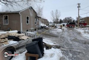 Valley City (CSi) The Valley City Public School District has established a fund for the David and Lesley Erlandson family following the Wednesday night explosion and fire on February 26th at their Valley City home.
While David, Lesley, and their two children (Logan-2018 graduate and Bo –8th grader) are safe and thankful to be alive, the family lost everything.
Family friend Kyle Roelfsema encouraged the community to help the family during this trying time.
Monetary donations to the Erlandson family may be contributed to the VCPS Central Administration Office, or First Community Credit Union in Valley City.
Valley City Public Schools
Central Administration Offices
460 Central Avenue N, Valley City, ND 58072
First Community Credit Union
115 5th Avenue NE, Valley City, ND 58072
Please make checks payable to David and/or Lesley Erlandson
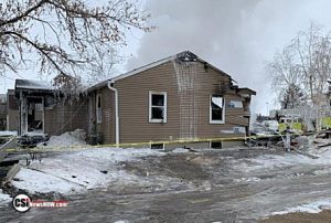 VALLEY CITY, N.D. (AP) — Authorities say a fire destroyed a home in Valley City and sent four family members to hospital. Fire Chief Scott Magnuson says that neighbors heard an explosion before the fire broke out about 9 p.m. Wednesday.
He says four people in the home were taken by ambulance to a local hospital with non-life threatening injuries. Magnuson says fire crews were still at the scene Thursday morning putting out hot spots. He says the house is a total loss.
WASHINGTON – (Sen. Cramer’s Office) U.S. Senator Kevin Cramer (R-ND), Chairman of the Senate Subcommittee on Fisheries, Water, and Wildlife announced Thursday the U.S. Department of Transportation (DOT) Federal Highway Administration awarded a $45,000 grant to the U.S. Fish and Wildlife Service in North Dakota.
The Emergency Relief for Federally Owned Roads program (ERFO) is authorized under U.S.C. 23 Section 125 (e) for the repair or reconstruction of Federal Lands Management Agencies transportation facilities. The intent of the ERFO Program is to pay the unusually heavy expenses to agencies that manage road systems for the repair and reconstruction of federal roads to pre-disaster conditions. Damage associated with the widespread heavy rainfall and flooding across the Midwest in April 2019 on Long Lake National Wildlife Refuge (NWR).
Update…
 BISMARCK, N.D. (AP) — The North Dakota schools superintendent is apologizing after being arrested on suspicion of drunken driving. The Highway Patrol says Superintendent of Public Instruction Kirsten Baesler was pulled over for DUI about 10 p.m. Wednesday on Memorial Highway in Mandan. The patrol has not said what led to the arrest. Baesler said in a statement that she made a “serious mistake” and is “deeply sorry” for her actions. She says she is going to seek help and focus on her well-being and health. Baesler was first elected in 2012 and re-elected in 2016. She has said she plans to seek another term.
In world and national news…
CHARLESTON, S.C. (AP) — Democratic presidential candidate Joe Biden is calling Bernie Sanders’ “Medicare for All” single-payer insurance idea “a long, expensive slog” with little chance of passage. Speaking Thursday at a small-town community health center in McClellanville, South Carolina, Biden countered with his “public option” government insurance plan to compete in the existing private market. The former vice president emphasized that his plan could benefit Americans who missed out on Medicaid expansion after the 2010 Affordable Care Act because their Republican governors declined to expand Medicaid. Biden said his public option would “automatically enroll” about 200,000 residents who would have been eligible for an expanded Medicaid insurance program under “Obamacare.”
GEORGETOWN, S.C. (AP) — While many of the remaining Democrats competing for their party’s nomination have spent the past few months spread out across the early-voting states, Tom Steyer has had a fairly singular focus: South Carolina. It’s a state where former Vice President Joe Biden has long led support, particularly among black voters, and a place where he’s said victory is crucial. As Saturday’s primary approaches, there’s concern that Steyer could be a spoiler who would blunt for decisive victory Biden needs to keep his campaign afloat.
WASHINGTON (AP) — As the campaign continues at full force, a poll from The Associated Press-NORC Center for Public Affairs Research asked Americans to say what word or phrase comes to mind when they think of top candidates for president, including President Donald Trump. For several of the candidates, a particular concept stands out. Americans think of Biden’s age, Bloomberg’s wealth, and Sanders’ left-wing politics. Several other candidates receive a mix of responses, and are still relative unknowns to the public. Descriptions of Trump are deeply divided by party, with Republicans using largely positive terms and Democrats using negative ones.
WASHINGTON (AP) — Vice President Mike Pence has announced that the State Department’s global health doctor will coordinate the U.S. response to the coronavirus. President Donald Trump put Pence in charge of the U.S. response, and on Thursday Pence named Debbie Birx, the administration’s global AIDS coordinator, as the White House coronavirus response coordinator. Birx joins an existing coronavirus task force led by Health and Human Services Secretary Alex Azar and will report to Pence. She was nominated to her State Department post by President Barack Obama. Trump sought to minimize fears as he insists the U.S. is “very, very ready” for whatever the COVID-19 outbreak brings.
DUBAI, United Arab Emirates (AP) — Saudi Arabia has closed off the holiest sites in Islam to foreign pilgrims due to the coronavirus. The decision disrupted travel for thousands of Muslims already headed to the kingdom. And it could affect millions more ahead of the fasting month of Ramadan and the hajj pilgrimage. Such a move wasn’t even taken during the 1918 flu epidemic that killed tens of millions of people. It shows the growing worry about the virus in the Mideast. Those afflicted in Iran include Vice President Masoumeh Ebtekar, better known as “Sister Mary,” who was the spokeswoman for the students who seized the U.S. Embassy in Tehran during the 1979 hostage crisis.
NEW YORK (AP) — Stocks took an early nosedive on Wall Street before recovering much of the ground they lost as investors struggle to anticipate how wide the economic damage from the coronavirus outbreak will be. The losses extend a weeklong rout that has brought the S&P 500 8.8% below the record high it set just a week ago. More companies including Microsoft and Budweiser maker InBev are warning their results will be hurt. The Dow Jones Industrial Average cut its loss to 370 points by the early afternoon after being down as many as 960 earlier as investors saw some buying opportunities.


Comments are closed
Sorry, but you cannot leave a comment for this post.