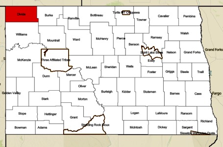
BISMARCK, N.D. – The North Dakota Department of Emergency Services, along with the North Dakota Forest Service, is pleased to publish a new Burn Restrictions Map. This interactive map displays daily restrictions for jurisdictional areas, such as counties and Tribal Nations, across the state.
“This is a significant improvement in user experience to help keep natural resources and people safe in North Dakota while recreating, farming, and using fire responsibly,” says State Forester, Tom Claeys.
Previously, citizens and tourists had to review information in three separate maps to determine if they could start a campfire. To add to the confusion, counties often did not share the same language within their restrictions. The new map is more user-friendly and will help clarify many of these inconsistencies.
The new map also reflects recent legislative adjustment to language used. Previously, ND Century Code used the term ‘burn bans’, whether they were a total fire ban or simply noted that some restrictions may be in place. Now these are referred to as ‘burn restrictions’, following the format set by many of the western states.
“We received numerous calls from the public: questions whether they could or could not have a campfire, people reporting their neighbor’s campfire even though it was perfectly legal, and complaints as to why they couldn’t have a campfire when they actually could. The language was just confusing,” says Darin Hanson, Homeland Security Division Director for the North Dakota Department of Emergency Services.
The new interactive map combines information including the daily fire danger rating, Red Flag Warnings, and burn restrictions provided to NDDES by local emergency managers. Selecting an area on the map identifies burn restrictions currently in effect. Users will also be able to enable their location to get this information in real time on their mobile devices.
NOTE: currently, local emergency managers are not required to post their burn restrictions in this system. In addition, incorporated cities may have their own permanent burn restrictions based on local ordinances. Therefore, citizens and tourists should verify the most current information regarding restrictions in their area prior to burning by contacting local fire departments or emergency managers.
To view the new and improved map and to learn more, visit NDResponse.gov/Burn


Comments are closed
Sorry, but you cannot leave a comment for this post.