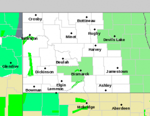
 Favorable thaw/melt condition to continue this week…loccal runoof likely to increase south of Fargo…
Light Green Shaded Area…March 25,2019
A slow and gentle melt continues across the Red River basin due to
favorable temperatures and dry weather conditions.
A warm end to last week and the first half of last weekend helped to
further ripen and eat away at the snowpack across the region.
Therefore, some areas have begun seeing ponding of water in fields
and ditches. Rivers and streams remain largely ice covered across
most of the region but with some open water, especially across the
far southern valley and into west central Minnesota.
Cooler air settled back into the region for the second half of last
weekend and the beginning of the new work week. This has helped slow
the onset of more rapid snowmelt and therefore further delay the
initiation of river flooding across the region.
The region will see high temperatures increase to above the freezing
mark yet again for much of the current week. However, overnight
temperatures are expected to dip below freezing (with possibly the
exception of Tuesday night) and continue to slow down the melting
process.
Little to no precipitation is expected over the course of the next
seven days. The increasing temperatures will likely contribute to
more locations seeing ponding of water. However, river flooding
is not expected to commence through the end of the week.
The last probabilistic outlook issued on March 15th remains valid
for the time being. This outlook incorporated average weekly
precipitation amounts of roughly one-quarter of an inch and an
average temperature regime. Thus far, the precipitation and
temperature pattern has been in agreement with these values (or even
slightly below).
There will be no additional probabilistic outlooks issued this
spring as we get closer to widespread melting and the issuance of
deterministic forecasts. However, an updated thaw progress statement
will be issued on Thursday, March 28th regarding the status of the
snowmelt, forecast weather conditions and the impacts on future
flood potential.


Comments are closed
Sorry, but you cannot leave a comment for this post.