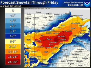
 Bismarck – The National Weather Service reports, Wednesday night, a potent mid level jet will intensify and eject over the southern high plains, spreads over the James River valley counties into south-central North Dakota overnight Wednesday and through Thursday evening. Over
southeast North Dakota a substantial period of heavy snow. A potential of 6-10″ in LaMoure and Dickey counties with 3-6″ elsewhere in the northern James River valley. Total snow accumulations of 5 to 7 inches for Stutsman County, with 7 to 14 inches for Logan, LaMoure, McIntosh and Dickey counties. 6 to 12
inches expected Clay-Barnes-Cass- Counties.
Blowing snow is also a concern as winds early Thursday morning,
becoming 30 to 40 mph in the James River valley through Thursday
evening.
In flooded areas, the high wind will remove wrning flags and signs, due to reduced visibility, making it difficult if not impossible to wee mud bogs, standing high water and holes in roadways.
Even with relatively warmer surface temperatures, visibility with blizzard conditions will still be a concern where heavy snowfall rates and strong winds coincide.
A Winter Storm Warning was issued to address both heavy snow and blowing snow possibilities.


Comments are closed
Sorry, but you cannot leave a comment for this post.