 Hazardous Weather Outlook Ntl Weather Service Bismarck ND 243 PM CDT Sun Jun 7 2020 Foster – Stutsman – Logan – La Moure – McIntosh -Dickey – 243 PM CDT Sun Jun 7 2020
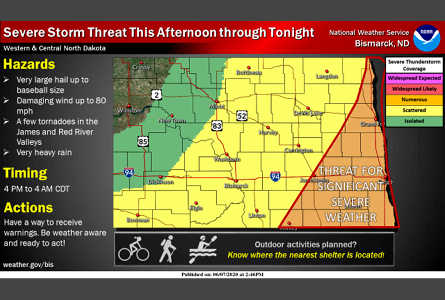
for portions of southeast North Dakota.
.DAY ONE…This Afternoon and Tonight
Numerous severe thunderstorms are expected across the southern James River Valley late this afternoon and evening. The main hazards will be a few tornadoes, destructive hail up to baseball size, and destructive wind gusts up to 80 mph. Very heavy rainfall is also likely with the storms.
.DAYS TWO THROUGH SEVEN…Monday through Saturday . The probability for widespread hazardous weather is low.
TORNADO WATCH OUTLINE UPDATE FOR WT 267
NWS STORM PREDICTION CENTER NORMAN OK
300 PM CDT SUN JUN 7 2020
TORNADO WATCH 267 IS IN EFFECT UNTIL 1000 PM CDT FOR THE
FOLLOWING LOCATIONS
.
NORTH DAKOTA COUNTIES INCLUDED ARE
BARNES BENSON CASS CAVALIER DICKEY EDDY FOSTER GRAND FORKS GRIGGS
LAMOURE LOGAN MCINTOSH NELSON PEMBINA RAMSEY RANSOM RICHLAND SARGENT
STEELE STUTSMAN TRAILL WALSH


Comments are closed
Sorry, but you cannot leave a comment for this post.